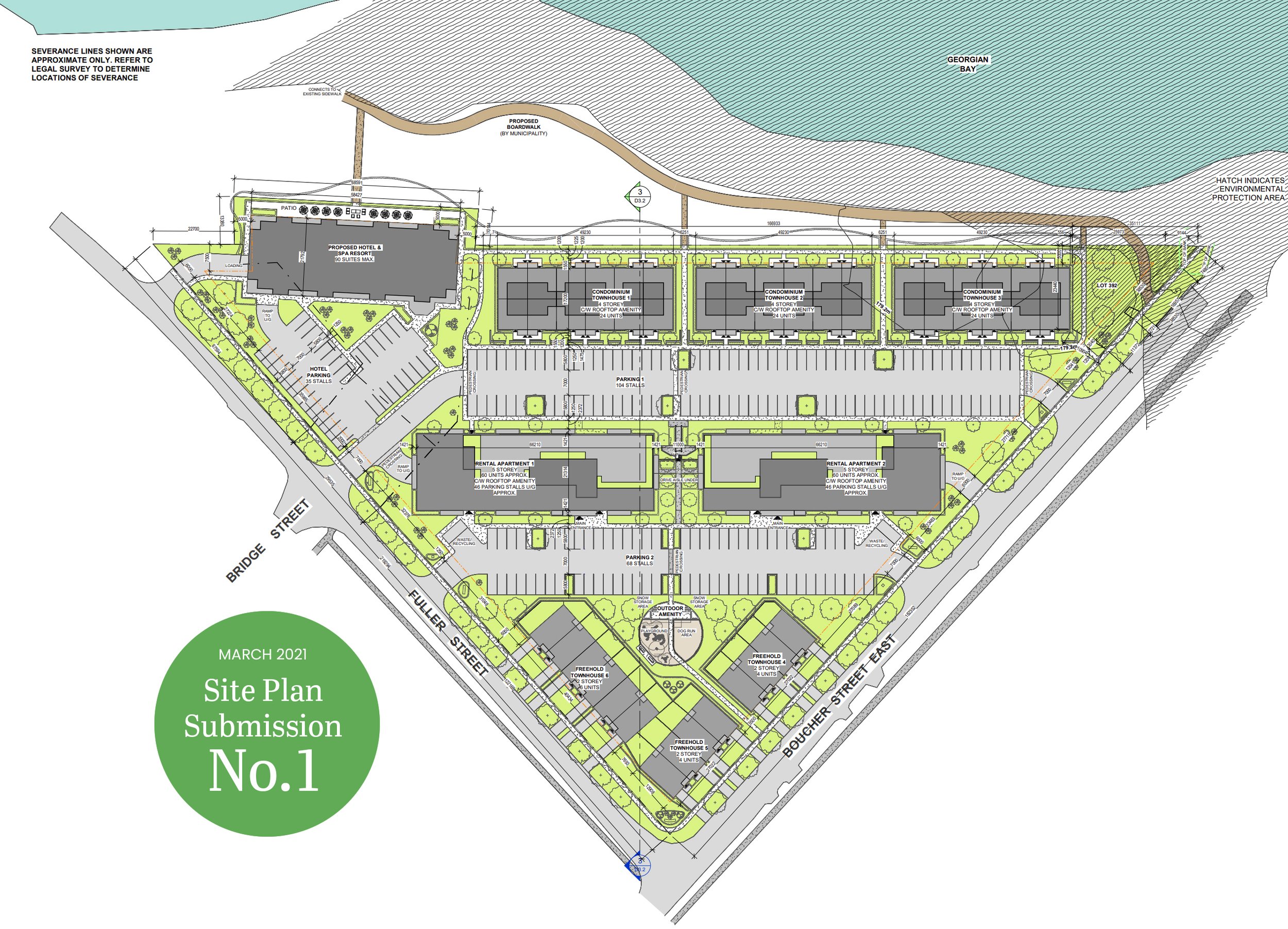
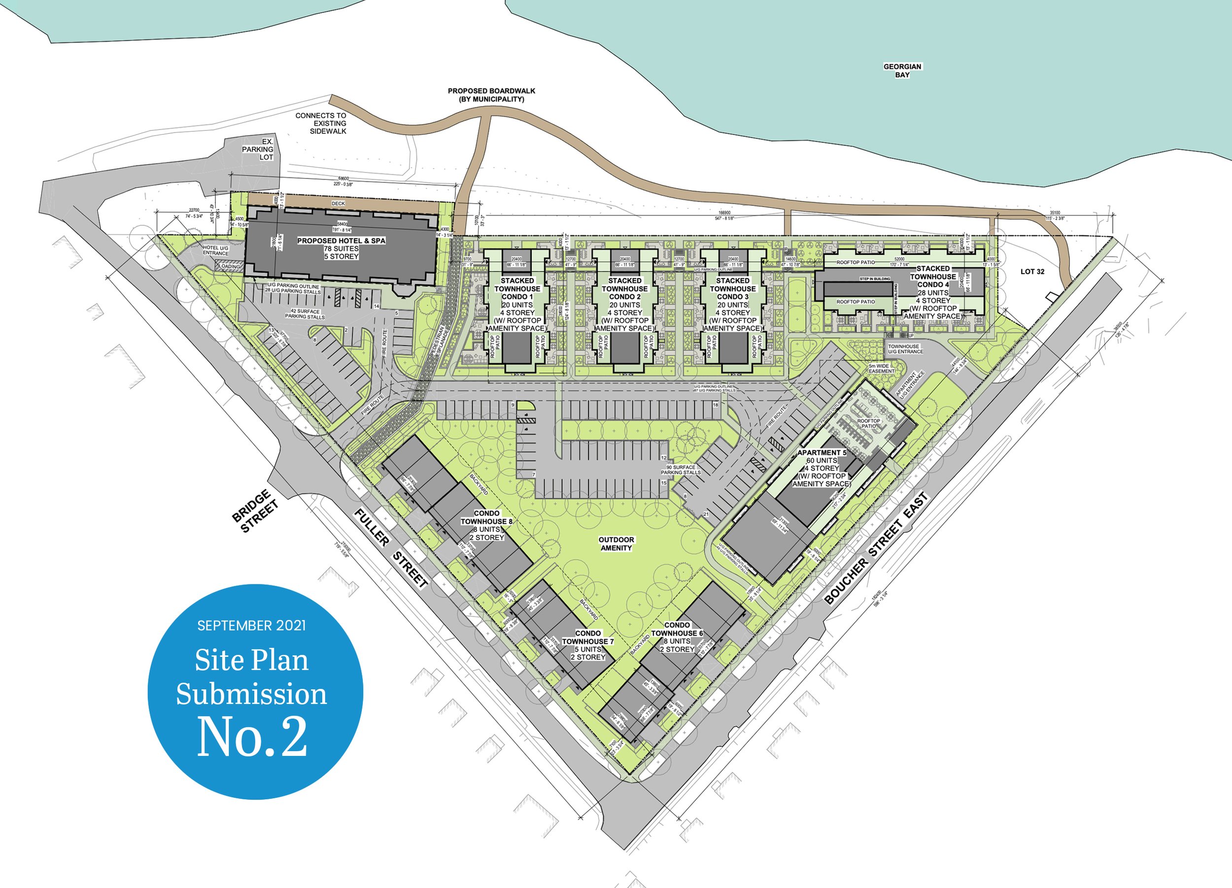
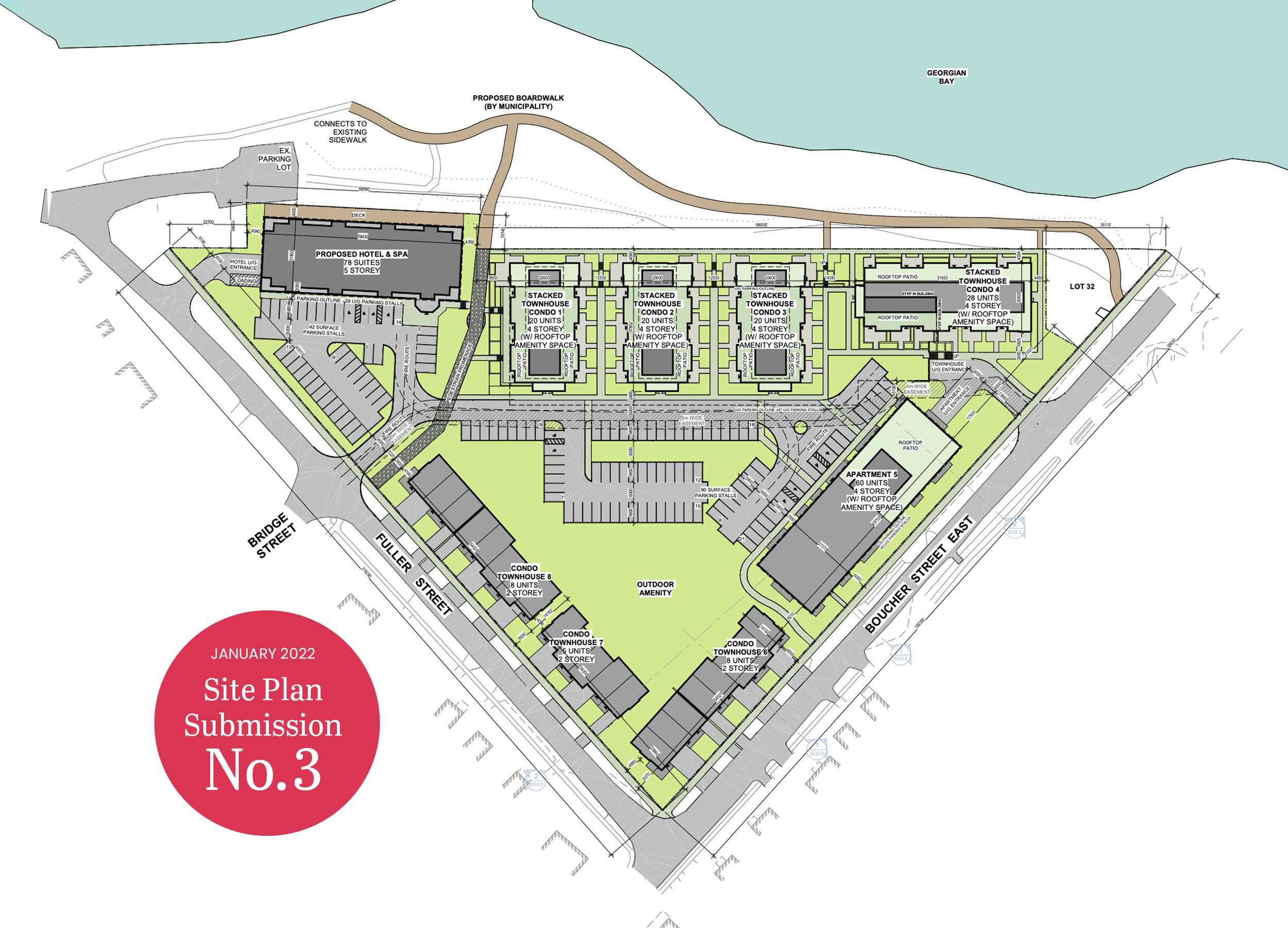
CRITICAL ANALYSIS REVIEW:
Aspects of SkyDev’s 3rd site plan submission (Jan. 2022) contravene Meaford’s Special Policy Area #1 of the Official Plan.
To view all 3rd submission documents click the button below.


SkyDev Waterfront Redevelopment — Zoning Bylaw Amendment – Z04-21
This land and proposed development falls under Meaford’s Official Plan — Special Policy Area #1 (see actual wording), which is specific to the area bounded by Bridge and Marshall Streets.
In response to the most recent (and likely final) submission from SkyDev, Imagine Meaford has identified key points of concern, many that have remained since the first submission and our initial correspondence.
Key Points of Concern:
Density and Height
The development as proposed does not meet Meaford’s Official Plan that specifically stipulates “new development is to be compatible, in terms of built form, with the character, size and massing of adjacent buildings and the adjacent neighbourhood.” The size, height and massing of the structures, and in particular the large buildings against the waterfront and along with the apartment, do not fit with the single family detached homes in the adjacent neighbourhood.
The applicant proposes to build every structure except the townhouses that face Fuller and Boucher above 3 storeys. We understand that a 3 storey, or 11 m height, is permitted as of right in Meaford’s Official Plan (s. D5) and we are not objecting to this height. However, the waterfront multi-residential buildings will present as 6 storeys from the water and will exceed even special permission to build up to 15.5 m in exceptional circumstances under stringent control (Meaford O.P. E.1.1.1) We respectfully suggest the applicant’s request for this increase in height cannot be supported. It is not necessary or appropriate to accommodate this proposed development (O.P. s. D5 (d)).
How is the term “4-storey” defined by the municipality?
According to the application, the applicant will be adding a significant amount of fill to raise the grade at waterside. In addition, the buildings will be designed to have a first floor at waterside with a parking garage that matches this grade, four additional storeys, plus an enclosed rooftop structure that will take up approximately 50% of the roof’s surface, thus creating a 6th storey (BELOW: see red markings on the applicant’s building cross section). Residents are struggling to understand how this fits within the height restrictions set out in the O.P. The applicant’s proposed zoning bylaw amendment does not clarify how a ‘storey’ is defined and it should be explained. The extra height—which will be well above a traditional 4 storey building—should be made amply clear in the bylaw and well-defined to the public and Council. This bylaw could set a precedent for future developments.
Detailed Cross-Section:
The applicant has not provided a detailed cross-section as part of its submission for re-zoning (see #34, #90 and #115 of the Meaford comprehensive matrix and answers by SkyDev, provided in the letter to the municipality dated January 21, 2022). The applicant instead refers to “visuals” it has produced (see #118 of matrix - pg. 24), which does not provide adequate information. A detailed cross-section is something the municipality, Imagine Meaford and other residents have requested from the applicant in the past in order to better understand the proposed heights and impact of the proposal (#120 of matrix - pg. 25).
We would request that the applicant provide a detailed cross section, through the site, showing all the proposed building heights compared to existing grades on both the beach and municipal roads. It would be most helpful for everyone who will be assessing the merits of the proposal. A typical plan view does not help a layperson fully understand how the buildings will appear when completed relative to the existing grade of adjacent public lands. Residents will not be viewing the buildings from above, once they are built, but from the beach and surrounding homes and streets.
We do not believe detailed cross sections should wait until site plan stage as the applicant has proposed, as under the Planning Act (Section 40) site plan is a non-public process. At site plan, the public and council are included “for information purposes” only as the applicant has indicated. That is why these details are being requested now — while this is still a public process.
The applicant has known for many months the intended elevations of the parking garage and first floors as well as the number of storeys it is requesting for each of the buildings plus the rooftop structures. With this information, a detailed cross-section could be produced now and the applicant’s hesitation is perplexing. While the applicant suggests some changes might yet be made to the layout of buildings, we note the applicant has not made any significant changes to the size or placement of the proposed buildings since late last summer.
Sun/Shadow Study:
In addition, we would like to know if SkyDev has provided a sun/shadow (or sun/shade) study for this proposal as per Meaford’s O.P. D7 (a). If yes, the Municipality should advise where it can be located. If no such study has been done to date, will the applicant be required to provide one prior to the matter coming before council? This is not an unusual request, especially when an applicant is requesting heights above what is permitted. Such tall buildings could create long shadows on the public trail and beach for much of the day which would negatively impact the public’s use and enjoyment of the adjacent public spaces as a public amenity.
Bonus Zoning through Community Benefit. Bonus Zoning is the authority to increase building heights if a developer can prove there is a community benefit.
The “community benefits” set out in the applicant’s letter (dated January 21, 2022) are insufficient to justify the request to build structures above permissible limits. View SkyDev’s “community benefits” letter.
Development charges & parkland dedication: The applicant suggests development charges, cash in lieu of parkland and road and streetscape improvements are justification for the additional height, yet these are not extraordinary gifts to the municipality. There are statutory charges required to be paid when a large redevelopment and zoning change takes place in urban municipalities in Ontario. For clarity, it would be helpful if Planning could provide the amount of the contribution expected (cash in lieu and development charges) and the formula showing how it is determined so we may understand the extent of financial benefit the community is actually gaining.
Construction of a waterfront boardwalk: We note that SkyDev is not actually constructing the public waterfront trail system described in some detail on the second page of SkyDev’s community benefits letter. Rather, this public trail will be built at the cost of the municipality.
Brownfield Remediation Provided as Justification: The applicant insists that “de-industrializing the waterfront" and remediation of a brownfield site provide justification for the development as proposed and alludes to "contamination of the existing site". We understand the historical use of the land was a hardwood flooring manufacturer with its ancillary uses as did the applicant at the time it agreed to purchase. What specific evidence has the applicant provided of significant contamination? The reports currently filed and available on Meaford’s website including the material found in the matrix at #111 do not suggest any sort of soil contamination beyond what could have been reasonably uncovered by the developer as part of due diligence prior to purchase. The previous uses of the land were well known. Soil remediation if any, would have been anticipated and costs built in from the outset. If the developer failed to take these costs into account, they should not now be borne by municipality in the form of approvals of excessive density and/or height (see matrix # 122 - pg. 25) to make a business case for the developer.
Opportunities to inventory, remove hazardous and/or non-native trees and vegetation, with appropriate new tree and landscape plantings; Any development or further use of this site would require these steps and landscaping is a mandatory part of any development process.
Streetscape Improvements: As above, these are typically part of a developer’s responsibility to complete a site with sidewalks, street trees etc.
Environmental sustainability elements: This element should not be treated as a benefit but as a MUST component of all future developments.
Hotel: We note the municipality’s request to the applicant for information about the mechanism it believes might work to ensure delivery of a hotel on the site. The applicant puts forward Zoning Bylaw Amendment 3(a)) as a trigger to release the “H”(holding) provision which we find is unacceptable. This mechanism should be determined by the municipality and how will Meaford ensure that the applicant does not simply build out the profitable residential portion and abandon the rest for business reasons? The holding provision should remain for a significant portion of the residential units until a permit has been issued for the hotel component, ensuring the hotel building is under construction with the hotelier under contract to the satisfaction of the municipality. We further note that arguably the most important part of the application — the hotel —has very few details, merely a vague assurance. No hotelier has been confirmed and the applicant advises that the promised spa use is “yet to be determined” (item #81 on the matrix - pg. 10). A restaurant on site has also yet to be determined. Residents remain very concerned about making the hotel and commercial components real.
Creating Safe and Attractive Pedestrian Access to Waterfront (Special Policy Area #1)
The development principles of the Official Plan state, “The development will create and improve linkages to existing open space and harbour lands…" SkyDev has also included this as part of their Community Benefits.
The proposed design fails to create a safe public pedestrian walkway to the waterfront through the site. The design shows that motorized vehicles entering site parking lots will cross over the main “pedestrian promenade” (the extension of Bridge Street), making this proposed pedestrian path unsafe for children and others with mobility issues. While labeled as a pedestrian promenade, it does not safely function as one. People should not have to move out of the way of moving cars or be diverted to less convenient pathways to the waterfront which the applicant has located at the very edges of the subject property. The improved pedestrian linkage to the waterfront should be public, safe, and easy to access.
Excessive Parking on the Site
This most recent proposal has not yet resolved the issue of significant surface parking on the site (132 parking spaces shown above ground). It remains our position that the OP requirement found in Special Policy Area #1 and in particular B.1.8.1.2 (e) has not been met.
A reduction in the number of residential units proposed would also reduce the number of parking spaces required and re-engineering to park cars underground could be further explored as it has been successfully accomplished in Collingwood’s Shipyards Development , where parking is primarily placed underground and walkways to waterfront and public open space run through the development creating more green space.
The excessive surface parking also adds to the “significant increase in impervious areas on the subject property which would result in increased storm water runoff” which was noted by GSCA (#105 in the matrix - pg. 16). The landscaping buffer proposed does not appear to adequately solve the underlying storm water runoff issues. GSCA further recommends that vegetation be maintained on the Georgian Bay shoreline on the municipal property that directly fronts the subject lands as it provides ecological and hydrological benefits to Georgian Bay. It must also protect 30m setbacks from the mouth of Meaford Creek (see #111-112 of matrix - pg. 17). The applicant should provide details as to how it intends to protect and maintain this vegetation through staging and building? We note (as did GSCA) that the proposed setback of the waterfront buildings is almost at the beach side municipal property line.
There are other building layout options the applicant could consider beyond those shown by the applicant to date. Imagine Meaford provided an alternative layout option to the developer late last summer. Only a few ideas were incorporated by SkyDev. Our alternative layout showed the buildings placed at an angle to match that of Bridge Street and showed public open space at the waterside near the hotel, providing a tourism related open space as per O.P. B1.8.1.2 (b) rather than creating a “residents only” park at the centre of the site out of public view (see matrix # 126 on outdoor amenity - pg. 25).
Grading
The SkyDev proposal has four times the minimum density permitted by Grey County. In order to accommodate the parking required for that number of units and comply with the Official Plan’s Special Policy Area #1 for restricted surface parking, SkyDev has raised the whole property by up to 12 feet to accommodate underground parking garages. This could create a 10-to-12-foot wall along the lakefront by the municipal pathway. When you add the fifty-foot stacked townhouses it will create a virtual wall on SkyDev’s property. There will be over 6 feet of elevation difference between the first floor of two storey townhouses on Fuller Street and the sidewalk making them virtually three storeys (example shown on LEFT image below). SkyDev does not indicate this elevation difference on their visual (shown on RIGHT image below). The Official Plan clearly states “if large in scale, will not obstruct views of Georgian Bay along streets that terminate at or close to the water’s edge.” .
The Geotechnical Investigation Report does not appear to be updated for Submission 2 ( September 2021) or three (January 2022), only the original (dated November 20, 2020) remains. The original did not anticipate the substantial fill needed for integration of underground parking – it states: “It is assumed that only minor cut and or fill site grading operations will be required to establish subgrade levels and permit the construction of the proposed development.”
From the Functional Servicing Report 6.0 of SkyDev’s third submission states “The grading will also respect the existing elevations along all the property lines.”
The Cultural Heritage Impact Study
This is a “Scoped Report”, not a full study. The Report provided appears to be the basic fulfillment of a mandatory obligation in the Official Plan rather than an objective view which would show the striking incompatibility of this development with the intent and objectives of the Meaford Heritage Conservation District Plan.
Let’s ensure both the text and the intent of our Official Plan is followed.
WRITE TO: planning@meaford.ca and clerk@meaford.ca (please ask Clerk to distribute to Council & Mayor)
AND COPY your email to the following:
rvoigt@meaford.ca (Rob Voigt, Director of Development Services)
rarmstrong@meaford.ca (Rob Armstrong, CAO)
dmccarl@meaford.ca (Manager, Planning Services)
planning@grey.ca (Grey County)


